Villages of Higham and Shirland, Derbyshire
Location and History
The farming and coal mining district around these historic and picturesque twin towns was the birthplace of Mary Askew and other members of her Askew family. The towns are located between Derby and Chesterfield in the hilly countryside of north-east Derbyshire, and during the eighteenth and nineteenth centuries both were vigorous communities with strong local agricultural and mining industries. Today they are quiet residential villages, with some local hospitality and other services for residents and tourists. The important trades of the past, such as that practised by Mary Askew's father (the village "smithy") have either disappeared or been relocated to the larger nearby towns, such as Alfreton (to the south) or Chesterfield (to the north).
Gladwyn Turbutt's book "A History of Shirland and Higham" is the major reference to the district. Published in 1978 by the Ogston Estates, and printed by Higham Press Ltd, Shirland, Derbyshire, DE5 6BP the book of 308 pages, by a descendant of one of the important local families, traces the development of Shirland and Higham from Roman times, through a period as a thriving market community to the present. It includes excerpts from district directories and summarises data from parish records and census returns. An brief outline of the history is given below, with a few short quotations from those sections that relate directly to the Askews. Additional historical material is contained in a walk guide compiled by Tim Warner entitled "Country Walks in North East Derbyshire - Shirland and Higham" (North East Derbyshire District Council Community Programme). Warner's guide includes some of the information also contained in Turbutt's book.
The village of Higham is situated on an early Roman road, Ryknild Street, that follows the crest of a ridge on the main roadway between Derby and Chesterfield. At the southern end of Higham, the modern road and the Roman road converge for about 0.5 km before the A61 veers off to the south-east, leaving the course of Ryknild Street to be covered by a tree-lined, minor road. Further to the south of Higham, the trace of the Roman road can be seen in the alignment of hedges that form the boundaries of fields. Strettea Lane, which joins Ryknild Street close to site of the market cross, also reflects the Roman history of Higham, being derived from the Anglo Saxon and meaning "a lane which joins a Roman road". Higham, the "high village", overlooks the valley of the north-south trending River Amber, to the west, and has a broad outlook to the east towards the village of Tibshelf.
In 1243, Higham was granted a charter for a weekly market and annual fair and the market town flourished for about 500 years before slowly declining as larger regional markets became accessible through improved transport.. There is a village cross in the main street that was erected in 1856. This replaced an earlier market cross erected during the seventeen hundreds, and this in turn is believed to have replaced a cross within the medieval market place (Turbutt, 1978).
The Village Cross in Higham, Derbyshire
The Cross in the main street of Higham Village. The street, which follows the line of an old Roman Road, "Ryknild" Street, is lined on both sides with dwellings and public houses dating from the 17th, 18th and 19th centuries.
(Photograph Ask-hig-003, Russell Hudson 1993)
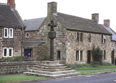
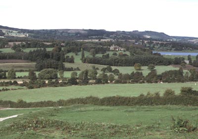
Today, the village of Higham preserves much of its historic character, reflected in both its general layout and in the design of its buildings. Both sides of the old Roman road are lined with dwelling houses and public houses, many of them built in the 17th and 18th centuries. These buildings have imposing stonework frontages, with smaller sheds and gardens behind. On the east of the road the dwellings and outbuildings back onto undulating open fields, and on the west they look out over a grassy slope towards the valley of the River Amber. Ogston Reservoir and the old Brackenfield village are important landmarks, as are the distant hills of western Derbyshire (see photograph, below).
Many of the old public houses are still in use, and are supported by trade from locals and tourists. My wife, our son and I stayed at a small B&B on the main street in September 1993. We visited both "Greyhound" public house (for evening meals) and the "Crown" (for drinks and an Irish band).
A Walk to Brackenfield and Wessington, Returning via Higham Mill and Ryknild Street
We also decided to follow Walk 3 in Tim Warners book (see above). The walk commenced from the Greyhound Hotel and took us down a bridle trail though farmland to the main Derby-Chesterfield railway line, across a small stone bridge on the River Amber to eventually reach the Brackenfield Church. Here we discovered a number of gravestones of Askew families who lived in the district during the eighteen hundreds. We copied inscriptions for James ASKEW, died 28 March 1845 age 60 years; also Robert ASKEW, died 11 July 1884 age 86 years, and his wife Sarah, died 18 June 1864, age 61 years; also Robert ASKEW, died 9 January 1892, age 59 years, and his wife Elizabeth, died 26 April 1918, age 86 years; and also Martha, wife of William ASKEW, died 24 September 1861, age 60 years.
The walk continued across fields and along roadways to Wessington and then to the Higham Dairy Farm, previously known as the Higham Mill. This mill was operated by water from the River Amber, that was directed via a mill-stream to a mill pond to the north of the mill. It remained in operation until the end of the nineteenth century, when it was converted to a dairy. Earth-works associated with the development of the railway line now separate the mill pond from the river. Turbutt (1978) records that Higham Mill was occupied as a farm by James Askew from 1933 and that his family purchased the property in 1952.
Our walk continued to a tree-lined road that follows the line of the old Roman Road back to the village of Higham.
View to the West from Higham
Beyond the stone buildings that line the western side of the main street of Higham is a scene of rural tranquility. Pastured slopes descend to the valley of the River Amber and beyond to the southern end of Ogden Reservoir. To the south of the reservoir is the Brackenfield Church, and within the churchyard are gravestones, a number of which carry inscriptions with the family name Askew (see above).
(Photograph Ask-hig-004, Russell Hudson 1993)
Records of Residents and Occupations in Higham
Turbutt (1978) records that the village of Higham was virtually self-sufficient during the late 19th Century, with a vigorous farming community supported by numerous village tradesmen, including licensed victuallers, grocers and shopkeepers, tailors, cobblers, tanners, saddlers, bakers, butchers, weavers, watch-menders, masons, malsters, wheelwrights and blacksmiths, together with a number of other trades and professions. Details of tradespeople in the village were reported by Stephen Glover (ca 1829) and further information is contained in Bagshaw's (1846), White's (1857), Kelly's (1876) and Bulmer's (1895) Directories of Derbyshire.
Glover (1829) gave a comprehensive view of the manor and parish of Shirland, which contained a population of 1694 and 234 dwelling houses and an area of 2901 acres (Turbutt, 1978, p158). Most lived in Higham and were supported by agriculture. He lists Thomas Askew (blacksmith) amongst the tradesmen of Higham. In the Samuel Bagshaw Directory for 1846 there was a Parish population of 1381 of which 451 lived in Higham, occupying 86 houses. There were no Askews listed in Higham, although William Hill was listed as a blacksmith, and those living at Shirland included Elizabeth Askew (blacksmith), "no doubt carrying on her late husband's business". In Francis White's Directory of 1857 the population of the Parish had decreased to 1857 (P 167) and the population of Higham had fallen marginally to 217 men and 200 women; James Askew (blacksmith) was listed (also James Askew farmer of Stonebroom). By 1876, Kelly's Directory showed the population of the Parish had risen to 2870 (doubling in 20 years), but the population of Higham had fallen further to 343; the blacksmith listed was Joseph Orme. In 1895, Bulmer's Directory gave a Parish population of 3694 (a 3-fold increase since 1857, mainly due to the sinking of the Shirland and Morton coal pits. The population growth was mainly confined to Stonebroom and Shirland. The Directory lists Joseph Hadfield, blacksmith (h Stretton). Kelly's 1936 Directory confirms the shrinking population of trade people in Higham, and lists George Hadfield, blacksmith and also James Askew and Son, farmers and corn merchants, Higham dairy.
Location of Thomas Askew's Blacksmith Shop
The location of the blacksmith shop, once occupied by Mary Askew's father Thomas Askew, is on the west side of the main street of Higham, close to where the A61 (the Chesterfield-Alfreton Road) deviates to the south-east from the alignment of the old Roman Road. A map compiled in 1884 shows the site as being opposite the intersection, its location being indicated by an arrow and labelled "Smithy". A plan of the village of Higham, (Turbutt, 1978, Fig. 24), indicates the occupancy of property belonging to G. Turbutt Esq. On this map, Thomas Askew's widow, Elizabeth Askew, is shown as the tenant of Lot 270 (6 acres), Lot 395 (6 acres), and Lots 397 and 398 (no area specified). Lot 270 is on the western side of the road, and Lots 395, 397 and 398 are directly across on the eastern side of the road, in the angular area of land between the main street and the A61.
Turbutt (1978) describes many of the older houses in Higham, including the 17th Century house at Ash Tree Farm (built in 1668). He notes that in 1724 the farm was an 11 acre holding in the tenancy of Jonathon Hill, and his widow held it in 1768. Between 1829 and 1840 it was occupied by William Hill, and that in 1823 there was a blacksmith's shop in the yard which was subsequently converted to a cowshed. Turbutt also notes (p 206) that the houses adjoining Corner Farm were demolished before the second world war, and that these houses were opposite the former blacksmith's shop, and included a house occupied in 1724 by Jacob Redfern, who by 1823 had been followed by Thomas Askew and by 1877 by Joseph Orme (also a blacksmith). He later describes the blacksmith shop (p 208) as follows: "The old smithy (Plate 34), which is shown on the plan north of Bull Farm and adjoining the cross-roads, was described in a schedule of 1823 as a "New Blacksmith's Shop" and was a 6 acre small-holding occupied in 1829 by Thomas Askew (who lived just across the road), in 1851 by Elizabeth Askew, and in 1877 by Joseph Orme. Local residents will remember it being used for many years as a blacksmith's shop by George Hadfield - who may be seen shoeing a horse (in 1910) in Plate 34 - before being demolished shortly after the second world war".
Other References to Askews given by Turbutt (1978)
Luke Askey/Askew was one of four Parish Officers (Church Wardens and Overseers of the Poor) who, on 26 10.1722, signed a "settlement note" acknowledging that Anne Baker of Higham in the Parish of Shirland is an inhabitant of the Parish of Morton and thereby entitled to relief for the poor if required.
In a note to Chapter 6 (p 233), Thos Askew is listed, amongst others, as a signatory to a note addressed to Henry Holmes, discharging him to keep off their land. The note was dated 23/10/1827.