William Hudson's Farm "Sunny Brow"
"Sunny Brow" Farm
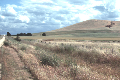
"Sunny Brow" farm, looking SSW from the road running past the old Lord Clyde School site, on Bullarook Creek (S), to intersect the main Clunes-Glengower road about 2 km SW of Glengower (N). The farm runs in a dark green swathe from the road to the west across the lower slopes of a group of extinct volcanic cones. With the sunlit northern face of the hill it is easy to see why William Hudson chose to name his farm "Sunny Brow". The farmhouse was in the group of trees near the road, left of the photograph.
Photograph Hud-clu-066, Russell Hudson.
Introduction
The land which was to become William Hudson's farm "Sunny Brow" was originally purchased from the Crown on 24 September 1863 by a W. Lane and two others, and they were recorded as the owners until 1866. The first Shire record of ownership in William Hudson's name only appears in 1873, but its probable that he acquired the property earlier than this, and his funeral notice in the Clunes Guardian and Gazette of 31 March 1908 suggests it could well have been about 1868.
The Voter’s Roll for 1872 lists William Hudson, farmer of Glengower, as being entitled to three votes within the Creswick Electoral District. In 1873, William Hudson is listed as a farmer of Smeaton, again entitled to three votes; in 1876 he was entitled to only two votes; in 1900 again the entitlement was two votes and the residence was listed as “Sunny Brow”, Lord Clyde, Clunes.
Following his death in 1908 the property remained in the ownership of William Hudson's widow, Mary Jane Goddard/Hudson. Her name appears on the roll until 1913, but the records of ownership after that date have not been found. It is known, however, that Thomas Edmund Hudson remained as manager for some years, and he is described in the Clunes School Records (during the 1920s and 30s when his children attended the school) as "farmer", "manager" and "overseer" of Lord Clyde (presumably on the farm "Sunny Brow").
From at least 1960 to 1980 and beyond the property was owned by Mr Joseph Fraser and Sons of Clunes, as part of a holding of some 6000 acres.
General Characteristics of the District
The towns of Creswick, Clunes and Campbelltown, in western Central Victoria, lie at the apices of a roughly-shaped triangle on the northern flank of the east-west trending Great Dividing Range, to the north of the city of Ballarat. Their origins are linked to the establishment of pastoral leases in the 1840s, and later, in the 1850s, to the purchase and development of freehold farms. In particular, however, their growth and prosperity depended on the mining of alluvial, deep-lead and quartz-reef gold deposits discovered in the early 1850s. Another town, Smeaton, also dependent on farming and gold, lies between Creswick and Campelltown, on the north-south base of the triangle described above, and the abandoned townsite of Glengower lies between Campbelltown and Clunes.
The oldest rocks of the district comprise deformed and recrystallised (metamorphic) rocks and granites that form the Great Dividing Range. In places, the metamorphic rocks contain gold-bearing quartz veins, or "gold-reefs". Processes of weathering and erosion over many millions of years has worn away part of these older rocks, and the gold previously contained in these rocks has been liberated and concentrated by streams and rivers flowing north from the Great Dividing Range. These concentrations at times were rich enough to form of alluvial gold deposits.
Younger basaltic volcanic rocks, represented by volcanic cones and extensive lava flows, intrude and cover some of the older rocks and their weathered and/or eroded equivalents, including some of the alluvial gold deposits in the valley floors. These buried gold deposits have become known as "deep-leads" and, in some instances the alluvial gold workings can be traced down-slope until they disappear beneath a thick basaltic lava flow. The location and mining of these buried gold deposits was difficult, expensive and dangerous, but sometimes gave rich rewards. For more details see the link to: Gold.
Weathering and erosion of the land surface has, of course, continued long after the volcanic eruption ceased, so that now the upper horizons of the lava flows have been converted to rich, dark basalt-derived soils. Such soils are characteristic of the "Smeaton Plains" where William Hudson's farm "Sunny Brow" was located. Beneath these soils, sequences of basalt flows (up to 100 metres thick, or more) overly the older metamorphic rocks and their associated soil layers and/or transported sands and gravels, including in places those gravels that have sufficient gold to become "deep-leads". One such group of deep-lead runs north from Creswick through Ullina towards Glengower, passing only about 2km to the east of "Sunny Brow".
Location of "Sunny Brow" Farm in the Lord Clyde District of the Parish of Smeaton
William Hudson's 45 ha (112 acre) farm was situated in the District of Lord Clyde, within the Parish of Smeaton, County of Talbot. The old property is located some 8 km north-east of Clunes, and can be reached by following the Smeaton Road from Clunes until, after about 4 km, it sweeps north towards a large volcanic scoria cone (Leishman Hill) and then turns east past the imposing Lord Clyde Homestead on the left to reach a road junction at about 6 km from Clunes. The cross-road runs from the south past the site of the old Lord Clyde school on Bullarook Creek, and continues north towards the main Clunes-Glengower-Campbelltown road. The site of "Sunny Brow" farm is about 2 km north of the intersection, just past the scoria cone, and is on the left side of the road marked by a group of pine trees, eucalypts and rambling garden plants.
Location of William Hudson's Farm "Sunny Brow"
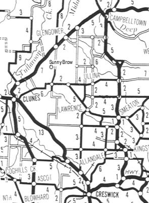
Map of the district bounded by Clunes, Campbelltown, Smeaton and Creswick, towns which were important during the farming and gold mining history in the west of Central Victoria. Other places of importance in the family history of William Hudson are: Coghills Creek (where he worked as a farm labourer); Ullina (where he was married); "Sunny Brow", his farm on the "Smeaton Plains" between Clunes and Glengower; Smeaton Cemetery, where the Hudson family grave is located (on the north side of east-west road half way between Ullina and Smeaton, opposite the number 4); and the site of the old Lord Clyde School (3 km south of "Sunny Brow", where the road crosses Bullarook Creek, a tributary of Tullaroop Creek.
(Photograph Hud-clu-001. Map is part of RACV "Central Southern Victoria", ~1980).
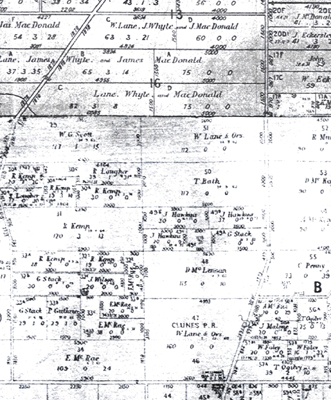
The subdivision of land in the Parish of Smeaton, County of Talbot is illustrated in a government plan of allotments drawn from the original plans in 1884, and subsequently checked and amended. "Sunny Brow" is shown on the plan as Allotment 51, a rectangular block, elongate east-west, at the northern margin of the Parish of Smeaton where it abuts the Parish of Glengower. The area of the land is 112 acres (~45 ha) and the dimensions are 56 chains x 20 chains (~1120 m x 400 m). The eastern frontage of the block is along the road from the old Lord Clyde School site to the main Clunes-Glengower road.
Aerial Photo and Land Plans for "Sunny Brow"
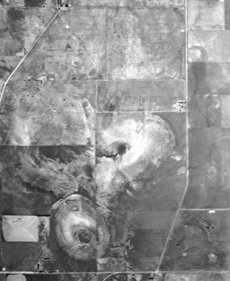
"Sunny Brow" farm is the elongate paddock above centre-right in the photograph, and is on the northern flank of one of three clearly-defined volcanic cones. The farmhouse was situated in the SE corner of the paddock, near the road in the group of trees.
Portion of land plans for Smeaton (lower two-thirds) and Glengower showing the original holding Smeaton 51 (112 acres) in the name of W. Lane and Others.
(Photographs Hud-clu-067 and Hud-clu-068)
Description of "Sunny Brow"
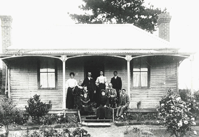
Some of William Hudson's older descendants have suggested that he may have lived in a tent on his property prior to the construction of his family home. The latter event is believed to have taken place about the time of his wedding in 1873, and the home was said to be "the first double-fronted farmhouse" on the Smeaton Plains. By about 1905, when the photograph of the farmhouse was taken, the property was well established and the gardens and trees were mature. The house faced towards the road, with an entrance drive, lined by shrubs, on the northern side. The front garden was filled with flowers, and fruit trees still can still be found in the both the area that was the front garden area and behind the site of the house.
"Sunny Brow", Lord Clyde, near Clunes
William and Mary Jane Hudson with some of their children on the veranda of “Sunny Brow”, Lord Clyde. Photo taken about 1906. Back row (L) are Victoria, Fred Jackson (visitor), Gertrude and John. Seated are Mary Jane Hudson, grandson Charles Henry, and William Hudson. Front row are Doris, Ruby Jane and Joseph Edmund.
(Photograph Hud-clu-005, probably about 1906; photographer unknown)
Little of the farmhouse remains today, but the eucalypts along the road, pine trees close to the house, remnants of an orchard, foundations, broken bricks. paths, floors of outbuildings, yards, wells, and wire and sundry old farm items provide mute testimony that this was once a thriving family home. In February 1988, I made a sketch of the area surrounding the home-site and recorded the location of some of the above items. I hope to include this sketch in a future update to the website.
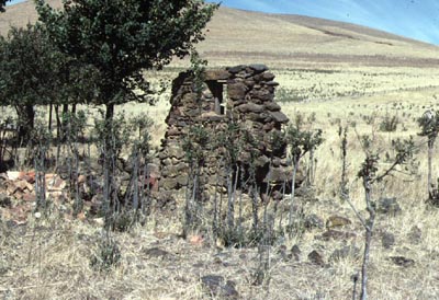
Remains of a Bluestone Wall, "Sunny Brow"
The site of the farmhouse is recognisable in aerial photographs and on the ground, but few of the original structures remain standing. An exception is a section of "bluestone" (basalt) wall containing a small window, possibly the remains of the dairy. The hill in the background is part of the volcanic cone, known as Leishman Hill.
Photograph Hud-clu-062 Russell Hudson, 1980)
History of Land Sales in the Creswick and Smeaton Districts
John Graham (1942) in his book "Early Creswick" gives details of the land sales in the Creswick and Smeaton Districts:
"When the fever of the gold rushes began to wane, attention was attracted to land settlement. The first recorded land sale in the Creswick district was held by the Crown on the 21st May, 1855. It comprised fifty-three lots, varying from 58 to 398 acres, situated in the Parish of Spring Hill, the total area being offered being 6,200 acres. The Age reported that 5,750 acres were sold for £8,475, the whole being purchased by three squatters, Messrs. Hepburn, Birch and Clarke.”
“The first sale of lands situated in the Smeaton district took place at Ballarat on the 14th July, 1856, and included part of Captain Hepburn’s run. The upset price was £1 per acre, but the “prices ranged between that and £6/17/- per acre, which was paid for Lot 46, purchased by Mr. M. Martin.”
A list of "original purchasers from the Crown" is given as:
|
Anderson, Wm. and David Calder, Alex Cowie, Robert Curtin, Patk. Dance, Jabez E. |
Dockery, Anthony Hepburn, John Lovett, Thos. McAlpine, Wm. Martin, M. |
Mather, A. Mather, R. Miller, Wm. Taylor, David Toose, Fred. |
Wilson, Andrew Woodhouse, G.M. |
“The total proceeds of the sale amounted to £28,063, the deposits of the purchase money paid at the sale being £2877, the balance, £25,186 being payable within one month.”
“Captain Hepburn purchased at various sales and dates an enormous amount of land. It was stated that at one time his holding aggregated about 30,000 acres, a large portion of it being rich agricultural land.”
Some other early settlers in the Smeaton district were (from "Early Creswick", page 127):
|
Anderson Askew Barry Barry, P. Bateman Brannigan Buchanan, J. Bunyan, J. Bunyan, W. Casey, P. Charleson |
Curtin Finlayson, P. Hepworth Hughes Judson, W. Kneale, T. McAlpine, J. McCrum, R. McNaughton McRorie, P. Marshall, J. |
Moran Muller, J. Mulquiney Nase, G.L. Pegler Postlewaite, J (sic) Pritchard, J.W. Redman, A.J. Ronaldson, John Sheehan, R.J. Smith, J. |
Taylor, G. Thistlewaite (sic) Toose, F. Toose, W.I. Westcott Whatmore, R Williams, E. Wilson, R. Those listed in bold type appear elswhere in the site. |
John A. Graham describes the difficulties facing the early settlers as follows: “The pioneers had a tremendous task in developing their farms. It has been said that if their labour had been paid for in wages, the cost of the land would have been equal to the market price. From the first glint of dawn until the fall of night they toiled incessantly, denying themselves everything but the essentials of existence, felling and grubbing trees, removing stones, ploughing, harrowing, fencing, and performing all the other necessary operations, and handicapped at the beginning by terrible roads. The womenfolk worked as laboriously as the men in household duties, rearing their families, milking the cows and churning the cream. With the sale of butter and eggs they provided the cash requisite to provide the household in food and clothing.”
Notes on Some Other Farm Holdings on the Smeaton Plains
Land plans that show the original ownership of "Sunny Brow" farm by W. Lane and others, also indicate that a T. Hudson owned a farm of 59 acres in the southwest corner of the Parish of ?Campbelltown, and a T. Askew (believed to be Thomas Askew, the brother of Mary Askew) owned a farm of 44 acres some 20 chains to the south, near the township of Ullina, in Smeaton. T. Askew also owned another property of 74 acres, situated 3 chains further to the east, and separated by small holdings in the name of J. Muller. All these properties are about 2 miles due east of “Sunny Brow” along a gazetted, but unformed road, and any of these, or the nearby water reserve on Middle Creek (where Mary Sinclair/Goddard lived), may have been used by William Hudson to feed his stock. Gertie Wolfenden remembers that for a period he leased a property of about 20 acres, and described how William Hudson would drive his stock, often including a pig with a rope on its hind leg, out for agistment to a property to the east of the farm.
The Eckersleys, who were close friends of William Hudson, also had several properties in the district. John Eckersley had two blocks (41 and 59 acres), and W. Eckersley one 59 acre block that were 10 chains north, and on the east side of the road on which Sunny Brow was situated. J. Eckersley also had two blocks (69 and 79 acres on the Clunes-Smeaton Road, adjacent to Bullarook Creek.