Tillshole
Tillshole Farm, Longsleddale
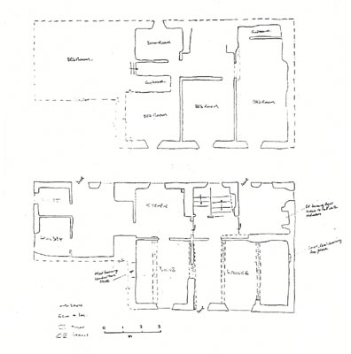
The view across the valley of Longsleddale, taken from the western slope above Tillshole. The stone cottage, built in a number of stages, is on the right, and sheds for wintering stock are on the left. The River Sprint runs across the centre of the photograph from left to right. The road into Stockdale is on the eastern side of the valley, in the top left corner. Note the "copper" beech tree beyond the cottage, and dry-stone walls in the foreground that continue up the valley side.
(Photograph Hud-lon-021, Lawrie Davidson, 1981)
Location of Tillshole
Towards the northern end of the valley of Longsleddale is a group of farmlets comprising Tillshole, Toms Howe, Stockdale, Lower Sadgill and Sadgill. The Hudson family occupied and worked in these properties from at least the mid-to-late seventeen hundreds, and census records show that Thomas Hudson and Isabella Green and/or their descendants were at Tillshole and neighbouring farms until after the 1881 census. No Hudson family members were listed at the northern end of the valley at the time of the 1991 census.
Tillshole (also listed as Till’s Hole) is 300 acre farm on the west bank of the River Sprint, towards the end of the valley of Longsleddale. There is a limited area of flat to gently sloping ground along the river bank, before the sides of the valley steepen to the windswept and barren upper slopes. In common with all of the farms in the valley, the fields are delineated by dry-stone walls that appear to date back to the earliest days of settlement of Longsleddale. The main road up the valley is on the eastern bank of the river and access to the farm is via a narrow stone bridge that leads to a small cluster of stone buildings comprising the farmhouse and outbuildings for storage of fodder and winter accommodation for cattle (see photograph, above).
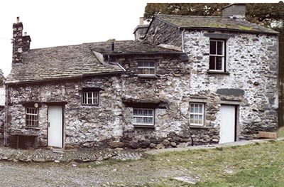
The farm was established at least as early as the seventeenth century and probably dates back to medieval times. Several stages of building are evident in the farmhouse, with both the nature of the stone-work and the design of windows being different in the additions from those in the original dwelling.
General Layout of Farm Buildings at Tillshole
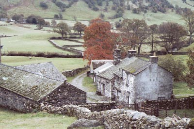
Sketch by Lawrie Davidson (1981) of the farm buildings at Tillshole. The position from which the photograph of "Tillshole Farm" and the valley of Longsleddale was taken is shown (see photograph Hud-lon-021, above). Also shown is the position from which the three photographs were taken to compile the panorama of north face of the Tillshole farmhouse. (see photograph Hud-lon-011, below)
(Photograph Hud-lon-220)
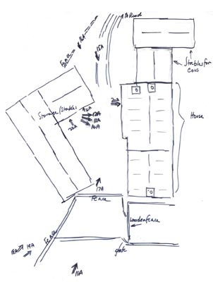
Topographic Map of the Northern End of Longsleddale, near Tillshole
Portion of the 1:25,000 Scale Outdoor Leisure Map of Windermere and Kendal (The English Lakes South East Sheet), Ordnance Survey, Southampton, UK.
(Photograph Hud-lon-210)
Composite Photograph of Tillshole
This composite view of the northern face of the farmhouse was prepared by joining three photographs taken by Lawrie Davidson in 1981. Despite attempts to correct for differences in perspective, some distortion remains in the image. Note that there are several stages in construction of the building.
(Photograph Hud-lon-011m)
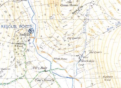
Sketch of the Floor Plan of Tillshole
My brother Geoffrey Hudson and his family stayed at Tillshole in 1983 at a time when the farm cottage was available for rental to visitors wishing to stay within the valley of Longsleddale. Geoff compiled this sketch of the cottage floor plan. Features of the cottage include the very thick stone walls and the black-painted, exposed, rough-hewn timber beams supporting the ceilings. (Note that the orientation of the sketch is inverted relative to the above photograph, and the ground floor is in the bottom sketch).
(Photograph Hud-lon-221)